Background
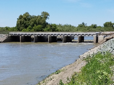
Downstream view of Wallace Weir.
In 2013, a large number of adult Chinook salmon were observed within Colusa Basin Drain (CBD) in various agricultural diversions and drainages. Because fish that enter these drainages are unable return to the Sacramento River, the Department of Fish and Wildlife (DFW) implemented rescues within the Colusa Basin canals and over 312 salmon were rescued. Analysis showed that a large portion of the rescued salmon were endangered winter-run Chinook salmon.
There has been a great deal of effort to examine environmental conditions and water operations which caused Chinook salmon to become entrained in the CBD during 2013. Numerous anadromous fish species have been documented in the Yolo Bypass (Bypass) following high flow events that overtop Fremont Weir. This is likely due the attraction caused by the large volume of water conveyed through the bypass during an over topping event. Anadromous species observed in the bypass after such overtopping events include state and federally listed species:

Central Valley winter-run Chinook salmon – State and Federally listed as endangered
Central Valley spring-run Chinook salmon – State and Federally listed as threatened
Central Valley Steelhead – State listed as threatened
Southern Distinct Population Segment of North American Green Sturgeon – Federally listed as threatened
Other native anadromous species that are listed as species of special management concern by the state and are also targeted for rescue and salvage efforts include:
Central Valley fall-run Chinook salmon
Central Valley late fall-run Chinook salmon
White sturgeon
The rescues that occurred in spring of 2013 occurred after a prolonged period of below average flows in the Sacramento River and without any over topping event at the Fremont Weir suggesting there may be strong attraction cues into the CBD occurring during periods outside of flood conditions. Possible entry points into the CBD watershed include: the Knights Landing Ridge Cut (KLRC) via the Tule Canal originating in the Cache Slough complex, and the Sacramento River through the Knights Landing Outfall Gates (KLOG). Irrigation returns and flood runoff from the west side of the Central Valley drain into the CBD which conveys water to KLOG, where a portion of these flows can be discharged into the Sacramento River under most conditions. The remainder of the water drains into the KLRC. If stage height of the Sacramento River at Knights Landing is greater than approximately 27 feet, then the outfall gates are closed and all flows in the CBD are directed into the KLRC, which ultimately discharges into the north Sacramento-San Joaquin Delta. It is believed that both flow routes have the potential to attract anadromous species into the CBD though KLOG and have been identified as far back as the 1970’s as entry points into the CBD.
To address the issue of entrainment into the CBD watershed and to better understand conditions resulting in entrainment, DFW designed and has annually installed a resistance board style fish weir and an associated fish trap in the CBD approximately 14 miles upstream of the town of Knights Landing. To better document utilization of the two potential entry points for fish into the CBD and increase the overall ability to capture salmonids, other locations in Yolo bypass were evaluated for capturing entrained fish. The DFW, in coordination with the California Department of Water Resources (DWR), installed a 10’ by 20’ fyke trap in the KLRC, downstream from a water control structure known as Wallace Weir in the Yolo Bypass on 22 January 2014. This site was selected primarily as a location to target and rescue fish entering the CBD through the KLRC and because of good access across a range of conditions in the Yolo Bypass.
These efforts provided guidance for design and installation of a much larger and permanent collection facility at Wallace Weir. An effort put forth by multiple agencies was made to make improvements to Wallace Weir as partial implementation of the National Marine Fisheries Service (NMFS) Biological Opinion and Conference Opinion for the long term operations of the State Water Project (SWP) and Central Valley Project (CVP), and Reasonable and Prudent Action (RPA) I.7.1 (reduce or prevent migratory delays in the Yolo Bypass for anadromous species).
Improvements to Wallace Weir include an increase in the top elevation of the berm by 3’ from its previous design, armoring the up and downstream sides of the berm with rip rap, an improved water control structure, and the addition of a fish collection facility operated by the California Department of Fish and Wildlife to salvage adult salmonids and sturgeon from the KLRC. These improvements allow for more control over flows going through the weir under a broader range of conditions and also allows for salvage efforts to occur under a broader range of flows. Salvage efforts will be easier to execute with the new collection facility compared to the fyke trap used downstream of Wallace Weir in previous seasons. The collection facility includes a crowding rack that concentrates fish into a holding area with a floor brail that staff can lift up from the bottom of the collection facility to the surface of the facility. Staff can then remove fish from the holding area to a work up station where they will be processed. Improvements to the weir also include a modified concrete box culvert with automated Obermyer gates to control flows and metal pickets downstream of the gates to block upstream fish passage.
Future implementation of restoration projects throughout the Bypass, such as Wallace Weir, will help water operations in the bypass to comply with the NMFS 2009 Biological Opinion and Conference Opinion for the long term operations of the SWP and CVP and the requirements of RPA I.7.1.
Description
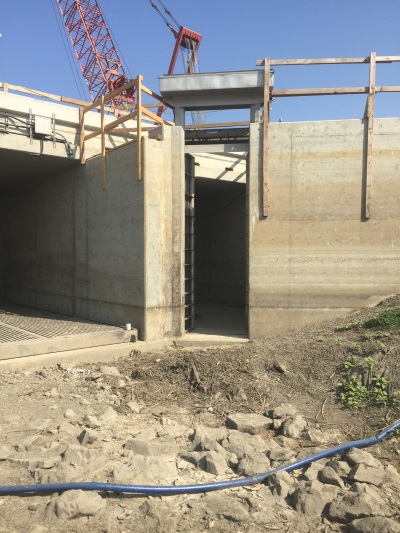
Entrance to the fish collection portion of the new Wallace Weir.
Salvage efforts in the Knights Landing Ridge Cut (KLRC) will be carried out via the fish collection facility associated with Wallace Weir. The collection facility is located on the northeast end of Wallace Weir, adjacent to the flow control structure. The collection facility consists of a 60 foot long by 6 foot wide entrance pool and a holding pool, measuring approximately 25 feet long by 8 feet wide. Within the holding pool is a manual fish crowder and a 10 foot long by 8 foot wide brail floor used for concentrating fish into a reachable area of the holding pool for field staff. A screened intake upstream of the holding pool draws water into the collection facility at a maximum rate of 45 cubic feet per second (cfs).
Salvage efforts out of the collection facility will begin in early fall and go until late spring/early summer, depending on water quality and observed presence of anadromous species. Field staff will visit the collection facility daily. Duties performed during daily visits include checking for and removing debris from the screened intake of the collection facility, measuring and recording environmental conditions, checking and documenting catch in the collection facility and transporting anadromous species back to the river.
Fish will enter the collection facility at the downstream end of the entrance pool and swim through two sets of gates that will direct them to the holding pool. A crowding rack and metal floor brail housed in the holding pool will be used to concentrate fish towards the upper section of the water column, where they can be reached by personnel with nets. Salmonids and sturgeon captured in the facility will be identified, measured, enumerated and examined for any marks and/or tags. Once anadromous species have been processed, they are loaded into either a transport trailers or transport tank and are taken back to the Sacramento River to be released. Resident species will be identified, enumerated and released back into the Knights Landing Ridge Cut Slough.
Anadromous species will be internally and externally tagged so that they can be tracked post release. Individually numbered t-bar anchor tags will be applied externally to salmonids. Passive Integrated Transponder (PIT) tags and Vemco V13 or V16 acoustic transmitters will be implanted internally into anadromous species. Fish with acoustic transmitters or PIT tags will be tracked post release using acoustic receivers and PIT tag antenna arrays that have been installed in known spawning tributaries and hatcheries. Detection of fish that are only tagged with t-bar anchor tags is reliant upon the recovery of the tagged fish by anglers, hatchery staff and researchers performing Chinook salmon escapement surveys. Tagging and tracking of fish provides insights to survival, migration and behavioral patterns post-release.
In the event that the Wallace Weir fish collection facility becomes inoperable or conditions at Wallace become conducive to upstream fish passage, the department can utilize two different temporary trapping methods and locations that have been used in previous seasons salvage efforts: a resistance style weir in the Colusa Basin Drain (CBD), upstream of the terminus of the canal at the Knights Landing Outfall Gates (KLOG), and a fyke trap in the KLRC. Both traps were typically installed in the fall and operated until late spring, conditions allowing. Fish captured in the resistance style weir fish trap and the fyke trap are processed in the same manner as described for the Wallace Weir collection facility.
The resistance style weir used in the CBD is made up of a series of panels consisting of PVC pipes that are strung together across the width of the channel. The panels have a one-inch gap between each of the pipes that allows water to flow through, but not adult fish or debris. One end of the panels is anchored to the substrate with a steel cable. The other end is floated with a plastic barrel. The floatation and anchoring system allows for the panels to sit at an incline in the water column to block fish passage, and facilitates easy removal of debris that accumulates on the upstream side. Floatation on one end also allows for the panels to adjust to changes in the stage height of the canal. The panels funnel fish to the middle of the channel, where there is an opening in the panels that leads to an enclosed metal picket live well where fish can be collected.
The fyke trap used in the KLRC consists of a 10’ by 20’ cylinder made up of metal tube framing wrapped in cyclone fencing and plastic mesh. One side of the fyke is open, and leads to two concentric cones that face inwards towards the closed end of the trap. Both have openings that allow for fish to swim into the enclosed spaces between the cones. These inward facing cones act as a behavioral mechanism to prevent adult fish from escaping the trap. The back end of the cone has hinged panel doors that allow staff to access the inside of the trap and collect trapped fish. The fyke is placed in the middle of the canal and is positioned between two wing walls, which close off the spaces between either side of the fyke and both banks of the canal, preventing fish from swimming around the trap.
Wallace Weir and Colusa Basin Drain (CBD) Trap Sites
*Tip: If the map is not fully loading or you can't see the location points, please try refreshing your browser window.
Please click on a trap site

to see its name. Zoom-in to view imagery of the location.